Snow in Plymouth

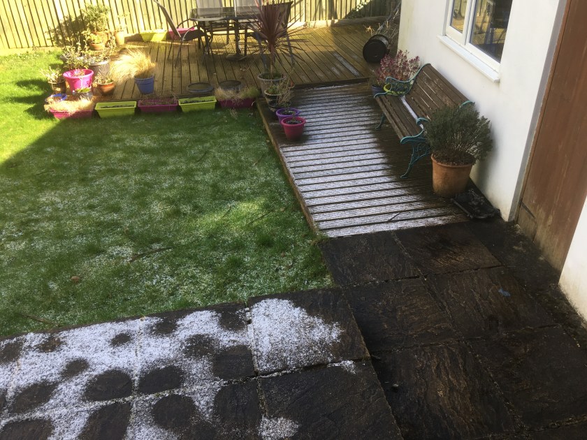
Situated as it is in the southwest corner of the UK, in the path of relatively warm ocean currents (Gulf Stream/North Atlantic Drift), Plymouth experiences a generally mild and wet climate. We do get freezing conditions at times but you can probably count the number of days of heavy frost, icy pavements etc. each year on the fingers of one hand. This means that when it snows in Plymouth it is an occasion of great excitement. In fact, the local newspaper website goes apoplectic at the prospect of a few flakes of the white stuff as if this will be the start of a ‘The Day After Tomorrow’-like big freeze bringing everything to a halt and catastrophe at every turn. But the fact of the matter is that it simply doesn’t snow in Plymouth, ever, at least not such that you would ever notice…

…so imagine my surprise when I woke up late this morning (my cold has really taken hold now and I am off work) and looked out of the window to see the ground covered in the white stuff. Actually, ‘surprise’ isn’t quite the right word (neither is ‘covered’ now I come to re-read that last phrase) – ‘amusement’ would be a better one, because the local paper had finally got its wish and it HAD finally snowed in Plymouth. Look, here’s the (albeit slightly melted) proof:

Earth’s Weather 2013

I love this movie showing the Earth’s Weather 2013 as viewed by satellite from the WMO (World Meteorological Organisation). I have a similar movie from when I did an Open University meteorology course a few years back which focuses on precipitation rather than cloud, but I was never sure where it came from, and this new movie has quite a nice commentary that talks the viewer through the main features as they occur.

With this view of the Earth’s weather you get really good insight into how places such as the UK are located just perfectly to catch the near constant stream of mid-latitude storms that progress west to east around the globe, and can also clearly see the typhoon/hurricane season and the intense convective activity occurring (and pulsing daily) in the tropics. All in all, the movie provides a really great ‘big picture’ view of the planet’s dynamic atmosphere which will probably make you think a little differently about our own local weather in the future.

The Scent of the Night (and of rain)

I finished Andrea Camilleri’s Inspector Montalbano novel ‘The Scent of the Night’ yesterday. Like all these stories, the plot is not so much an investigation of a known crime, but rather it is a journey of discovery to find out what crime has actually been committed. Once this is established by Montalbano the crime investigation tends to sort itself out. I love the quirky humour that suffuses these books, particularly Catarella’s confusing messages. And I love the descriptions of Sicilian food, so much so that reading the books makes me want to visit Sicily and eat and eat and eat.

Whilst n the subject of the smell of things, I thought I’d mention a nice article on the Scientific American website on some new work on the smells associated with rainfall. Fresh rain and Sicilian food – that would be a nice combination.

Amazing cloud film

This is an entry I’ve been meaning to write for ages. Sometime a while back I stumbled upon a website for a Science/Art project called “A History of the Sky” by a guy called Ken Murphy. This project sets out to record the history of the sky as viewed from a fixed vantage point using a time-lapse camera. The camera films the sky each day taking a picture every 10 seconds and then the film from each day is displayed side by side on a big screen producing a mosaic-like effect in which each block of the screen is a day’s worth of sky change. The aim is to put screens in public arenas and, ultimately to show the full year in one go. It’s perhaps hard to get a real grasp of what this ends up looking like but you can read more about the project at its website which also include examples of a 42 day preview movies and a 126 day version which is also available to view in better quality directly on youtube (watch in full screen mode). The 126 day version is particularly good because it is a long enough period to be able to see the seasonal change in sunrise and sunset times between the earlier and later days in the sequence. I also really like the way that you can see the pinky/purple tinge of sunset enter each image just before the end of daylight and the image dropping out to black.

Personally, I think there is only one word to describe this piece of work and that (much over-used) word is “awesome”.

Sun Dogs

A couple of weeks ago I was driving back from dropping my younger daughter off at her football training. It was about 6.30pm and the route took me almost due west through Plymouth. Ahead of me, in the sky, were (high) Cirrostratus clouds blocking out the Sun as it dropped down towards the western horizon. Either side of the sun were two small patches of “rainbow” – in other words not actually portions of full rainbow arcs but small patches of rainbow coloured light glinting through the clouds, horizontally one on either side of the sun. It was a beautiful site and, of course, when I got home I went scurrying to my books and discovered that what I had just seen was an excellent pair of “sun dogs”, also known as “mock suns” or “parhelia”. They are formed by the refraction of sublight through hexagonal ice crystals (hence the observation of high clouds). According to my copy of “The Cloud Collector’s Handbook” a matching pair of sun dogs earns me 35 points! (TCCH is like an I-Spy book on clouds…).

For more on this kind of atmospheric optical phenomenon this Atmospheric Optics website is really excellent and contains explanations and lots of wonderful images. The entry on sun dogs is here.

Fractal forecasting

There’s an interesting piece in New Scientist, No 2733 [07 November 2009] outlining some new published research which has used satellite derived rainfall data to explore how atmospheric processes show the same patterns of variation whatever scale they are examined on. Such behaviour is called multi-fractal and basically means that if you look at something on a large scale you see a certain pattern of variation but then when you look in more detail at a smaller scale the same pattern shows up (an oft-quoted example of this are coastlines which show large-scale undulations/headlands/bays but which, when viewed more closely show similar undulations at smaller scale). Fractal behaviour is starting to show up in all kinds of data and processes.

Anyway, the importance of this finding for meteorology is that currently it is verydifficult to build numerical models which accurate forecast larger scale processes because the resolution of the models prevents accurate description of processes on smaller scales (and so these have to be added into the model as special parameterisations). If atmospheric processes are really fractal (an idea that was first suggested at least 80 years ago by Lewis Fry Richardson) then it will be possible to properly (or at least better) describe the smaller scale processes in numerical weather prediction models.

I’m a believer that much of the complexity that we observe in the real world is governed by relative simple underlying principles and behaviour and this research is an example of this occuring in practice.

A new kind of cloud?

Preparing for my recent lecture on clouds I came across this set of images on the BBC website [01 June 2009] along with a brief explanation of a campaign by the Cloud Appreciation Society (yes, I am a member) for a designation for a new type of cloud – “asperatus” (meaning “roughened up” or “agitated”). Click through the images in turn and read the captions to find out more (or just enjoy the REALLY awesome photos). There’s more on the campaign for asperatus clouds at the Cloud Appreciation Society website.

Cloud cakes

Anyone who has ever been a student on one of my courses will know that I do like to introduce the occasional gimmick or two – whether it be my use of a light sabre as a pointer in my “forces” lecture, sounding a bugle to highlight particularly important physical principles or … (further examples not disclosed so as not spoil the surprise for current students over the coming weeks!). Last week I think I surpassed myself though. At my first meteorology lecture of the year a few weeks ago one of the students came in with a plate of cakes that he was selling to raise money for a student group he is involved with. That put an idea in my head and with these particular lectures taking place late on a Friday afternoon I thought that a nice surprise for the students wouldn’t go amiss. So I spent last Thursday evening in the kitchen baking, but not just baking any old kind of cake. With last week’s lecture being all about clouds, it seemed appropriate to bake some cloud cakes. These were then taken into work and given out to the students towards the end of the lecture when I got to the section on exotic clouds.

You’re thinking I’m bluffing here don’t you? You want to see evidence don’t you?

So here you go… proof that I really am mad!

CloudCakes
My cloud cakes, each one with a pale blue sky background and a little piece of fluffy Cumulus!